
Written by TraderStef, Originally published Oct. 8, 2024 at CrushTheStreet – Updated Oct. 9
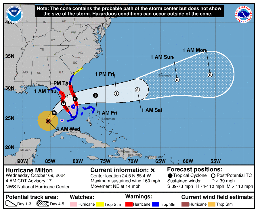
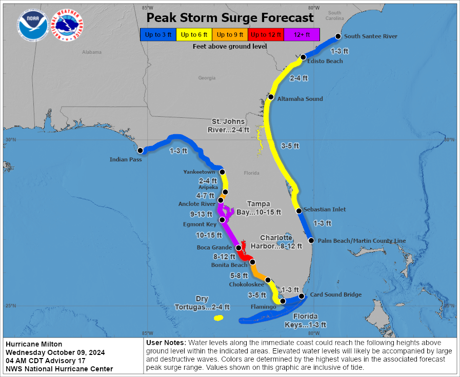
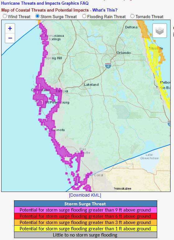
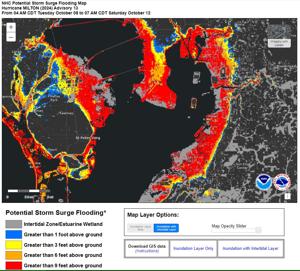
Less than two weeks after Hurricane Helene’s storm surge impacted Florida’s Gulf coastline killing 12 people and a storm surge wrecked communities near Tampa, Hurricane Milton has strengthened into a major hurricane and threatens a direct hit on the Tampa metro area with a population of more than 3.3 million people. Crews are still trying to clear as much debris as possible that remains due to Helene. Milton is expected to make landfall as a major category (CAT) 3 or 4 on the Saffir-Simpson Hurricane Wind Scale by Wednesday evening through Thursday. Interstate 75 traffic heading north is bumper-to-bumper as evacuees heed advice from the National Hurricane Center (NHC) to evacuate away from coastline communities and low-elevation inland areas within and near the forecast cone. Real time updates are available within my Twitter thread referencing this article.
The following North American hurricanes since 1935 are notable with record cyclone wind speeds that developed in the Atlantic basin:
- 215 mph: Patricia (2015)
- 190 mph: Allen (1980)
- 185 mph: Labor Day (1935)
- 185 mph: Gilbert (1988)
- 185 mph: Linda (1997)
- 185 mph: Wilma (2005)
- 185 mph: Dorian (2019)
- 180 mph: Mitch (1998), Rita (2005), Rick (2009), Irma (2017), Milton (2024).
- 175 mph: Andrew (1992)
In less than 24 hours, Milton bombed out (aka “bombogenesis”) north of the Yucatan peninsula from barely hurricane strength into a major CAT 5 that can cause catastrophic damage to property and severe storm surges. Rapid intensification is defined as a central pressure drop of 24 millibars (mb) within 24 hours. The National Oceanographic and Atmospheric Administration (NOAA) aircraft measured a pressure of 882mb in the center of Wilma, which printed the lowest pressure ever measured in an Atlantic hurricane.
“Bomb cyclones are not common, but also not rare. A 2021 study led by Robert Fritzen from Northern Illinois University found about 7% of all nontropical low-pressure systems near North America from 1979 to 2019 were bomb cyclones. That amounted to about 18 bomb cyclones per year, on average, near North America in that 40-year period… Frequently, nor’easters are bomb cyclones due to cold air surging southward from Canada combined with the warm ocean waters of the Gulf Stream.” – Weather Underground, Dec. 2022
Between 1pm Sunday and 1pm Monday, Milton’s sustained surface wind speed went from 80 mph to 180 mph with 220 mph gusts, and its central pressure dropped to a near record 897mb. Most of the intensification occurred within 12 hours, and it is one of the most rapidly intensifying storms on record in the Atlantic basin.

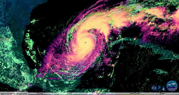
Last evening, Milton went through an Eyewall Replacement Cycle (EWRC) following the formation of a small 3.8-mile-wide “pinhole eye” and bombogenesis with rapid intensification that increased its strength to CAT 5 status. The storm maintained its structure during the cycle, its eye widened and cleared out quickly, and the storm’s status was only reduced to a high-end CAT 4 in the process. Milton is slated to cross over the warm Gulf Stream Loop Current later this evening through tomorrow.
“Hurricane Milton Advisory 14: Milton Forecast to Retain Major Hurricane Status and Expand in Size While it Approaches the West Coast of Florida.” – @NHC_Atlantic, Oct. 8, 11am ET
“AIR FORCE RESERVE HURRICANE HUNTERS FIND THAT MILTON’S INTENSITY HAS REBOUNDED… TODAY IS THE LAST FULL DAY FOR FLORIDA RESIDENTS TO GET THEIR FAMILIES AND HOMES READY AND EVACUATE IF TOLD TO DO SO. Maximum Sustained Wind 155 mph, Movement ENE at 8 mph.” – NHC Advisory 14A, Oct. 8, 2pm ET

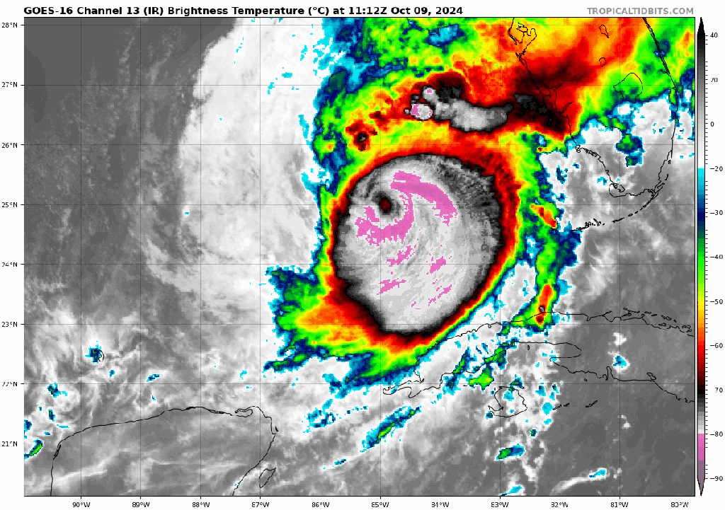
Despite all the chatter about dry air, potential shear lessening Milton’s intensity, and a possible second EWRC before landfall, the current satellite presentation looks like a strengthening hurricane with new convective bursts wrapping around its new 10-mile-wide eye. This storm is not unprecedented, but the last time a major hurricane impacted the area with a West to East trajectory, there were much fewer people. Furthermore, barrier islands were barriers, but they are now full of high-value real estate and a lot of bodies. The “buzzsaw” structure and strength of Milton foreshadows a nasty outcome and a large storm surge piling into Tampa Bay if the current storm track is on target. If you are anywhere that can get nailed by Milton’s fury, get out now!
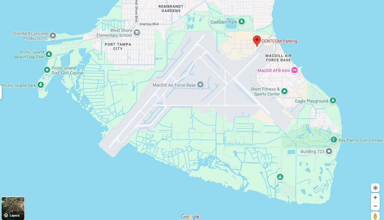
Lastly, those who decided to build the U.S. military’s Central Command (CENTCOM) and a strategic airbase barely above sea level on a peninsula in the middle of Tampa Bay were idiots.
“Update on Hurricane Milton: central pressure has fallen back to 920 mb since completion of the eye wall replacement cycle. Milton is on the way to secondary max in intensify right off the tip of the Yucatan – one of the most favorable areas for powerful hurricanes this time of year” – @ReedTimmerUSA, 4:49pm ET

As of Oct. 9 at 8am ET, Milton has exited the hot Gulf Stream/Loop Current where it re-intensified to CAT 5 following the first EWRC north of Yucatan. Hopefully we’ll see weakening before landfall tonight. The latest dropsondes still indicate CAT 5 status, but the most recent infrared presentation this morning is indicative of degradation and another EWRC taking place.
Ron DeSantis: Kamala trying to ‘politicize the storms’ – Fox, Oct. 8
Plan Your Trade, Trade Your Plan

Not a Financial Advisor: None of the content produced by TraderStef™, staff members, or any services associated with this website should be construed as financial or investment advice. Financial investment is a risky endeavor and may lead to substantial loss. Always perform due diligence before undertaking any financial decision – Copyrighted Material: A “by TraderStef” credit linked back to this website is required when using any quotes, technical analysis charts, or publishing a partial version of an article.


You must be logged in to post a comment.